 loading
Arts & CultureObject Lesson: Descendants of the AztecsA map once stowed under a dorm room bed is now in the Beinecke. Barbara E. Mundy ’84, ’93PhD, is an associate professor at Fordham University. Other contributors to Painting a Map of Mexico City include Miller, Magaloni, Gordon Whittaker ’80PhD, and Vanegas, who provided the illustrations. 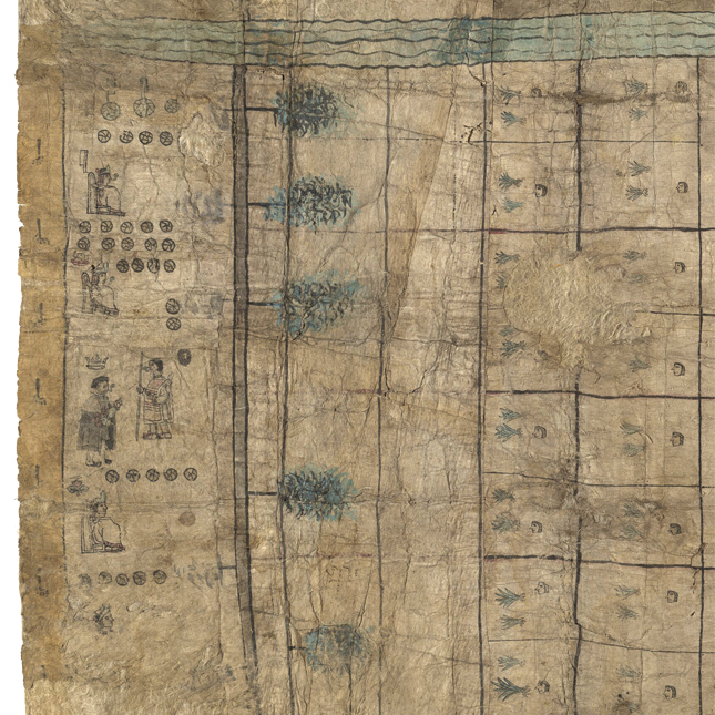 Codex Reese: Yale Collection Of Western Americana, Beinecke Rare Book & Manuscript Library.This detail from a sixteenth-century map shows several native lords of Mexico City and a Spanish viceroy. The rare map (about 29 by 70 inches) was unknown until it was spotted by a Yale undergraduate. View full imageIn 1974, William Reese ’77, an enterprising Yale sophomore, spotted a rare map in a furniture sale and placed a bid. It was not Reese’s first venture into the books and manuscripts trade—he is now a respected dealer—and his sharp eye would prove auspicious for both him and the Beinecke Library. He bid $800, won, and took the large rolled-up map home to his dorm room. There he kept it under his bed. About a week later, after showing it to Michael Coe of Yale’s anthropology department, he took it to the Beinecke’s director, Louis Martz, and its curator of Western Americana, Archibald Hanna Jr. ’39PhD, with an offer to sell. The price: the remainder of his Yale tuition. The map hung on the wall of the library without attracting much attention for almost three decades. Then, in the fall of 2001, along came Dennis Carr ’03MPhil, a graduate student in art history. His field, eighteenth-century American furniture, was a world away from sixteenth-century Mexico. But he needed a topic for a paper in a seminar, and the map fascinated him. He traveled to Mexico to meet local experts and took intensive Spanish in Guatemala, and there he met his future wife (and sometime collaborator), Olga Vanegas. In 2006 he organized a conference with Mary Miller ’81PhD—Sterling Professor of art history and one of the instructors for that original seminar—which brought together a group of scholars to study the map. One of them, Diana Magaloni ’04PhD, is a leading expert on Mexican pigments. She and Miller (who is now dean of Yale College) urged the Beinecke to allow testing, and in 2007, minute samples were taken from the map. Since then, it has undergone the most extensive testing ever carried out on a sixteenth-century manuscript from the Americas. Magaloni found that the artists were interested in the meanings of the materials they were using, which she connects to their larger world vision. For example, the map’s depiction of muddy ground appears grey to the eye, but it contains significant admixtures of a precious blue pigment called Maya blue, which is associated with water. Magaloni describes her research in a chapter of Painting a Map of Sixteenth-Century Mexico City (of which I am a coauthor), an illustrated volume on the map published by the Beinecke in 2012. For Carr, who is now a curator at the Museum of Fine Arts in Boston, connecting with different generations of Yale scholars was one of the joys of his work to help “unlock the mysteries of this important document.”
The comment period has expired.
|
|
 Print
Print Email
Email